Friday, February 23, 2024

Week 5 Volcanoes Hazard of Iran


Volcanic mountains form due to the eruption of molten material and the accumulation of such material. An explosion occurs when the pressure of gases and molten rocks in the Earth's core becomes excessively high. Outbreaks can occur slowly or explosively, accompanied by molten material flows, toxic gases, ash emissions, and volcanic fire. Iran has five volcanoes: Damavand, Sabalan, Taftan, Bazman, and Sahand. Out of these, Bazman, Taftan, and Damavand are considered active volcanoes.


Bazman

 (stratovolcano 3490 m / 11,450 ft)
Bazman volcano is a stratovolcano in SE Iran, 180 km SSW of the city of Zahedan. The volcano has a well-preserved 500 m wide summit crater with minor fumaroles, which suggest it could be still active. 

Bijar Volcanic Field

 (Pyroclastic cone(s) unknown)

Damavand

 (stratovolcano 5670 m / 18,602 ft)
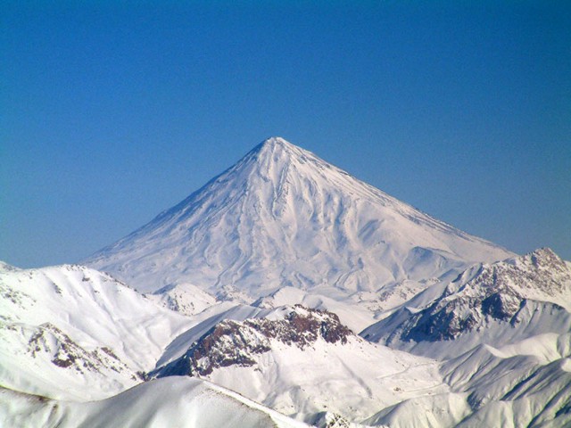
Conical snow-capped Damavand volcano is the highest volcano in the Middle East. It towers dramatically 70 km to the NE above Iran's capital city of Tehran. Activity at the 5670-m-high stratovolcano has been dominated by lava effusion. Young lava flows erupted from the summit vent blanket the western side of the volcano, and the youngest dated lava flows were erupted about 7000 years ago. Photo by Arad Mojtahedi, 2006 (http://en.wikipedia.org/wiki/Image:Damavand_in_winter.jpg)
Damavand volcano is a majestic stratovolcano located 70 km NE of Tehran and 70 km south of the Caspian Sea. Mt Damavand is the highest peak in the Middle East and the second highest volcano in Asia (after Kunlun volcano in Tibet).
Damavand last erupted about 7,300 years ago... [more]

Dehaj-Meduk

 (Volcanic field unknown)

East Neh

 (Unknown unknown)

Gandom Beryan

 (Unknown 500 m / 1640 ft)

Kuh-e Ayyub Ansar

 (Lava dome 2506 m / 8222 ft)

Qal'eh Hasan Ali

 (maars unknown summit elevation)
Qal'eh Hasan Ali volcano is a group of 14 maars about 5,000-50,000 years old in SE Iran. The maars range from 150 to 1200 m in diameter. The largest of the maars Great Crater, 1.2 km wide and 200-300 m deep. 

Sabalan

 (stratovolcano 4811 m / 15,784 ft)
Sabalan volcano (Kuhha-ye-Sabalan) is a massive andesitic stratovolcano in NW Iran, 80 km west of Caspian Sea and west of the city of Ardabil.
It is the second highest volcano of Iran (after Damavand volcano) and the highest peak in NW Iran. Sabalan volcano has 7 glaciers c.

Sahand

 (stratovolcano 3707 m / 12,162 ft)
Sahand volcano (also known as Kuh-e-Sahand) is a stratovolcano in NW Iran, about 60 km east of Lake Urmia (Azarbayjan-e Gharbi) and 40 km SSE of Tabriz city.
There are no known historic eruptions, but the volcano is possibly still active and has probably erupted within the.

Shahsavaran

 (Volcanic field unknown)

Taftan

 (stratovolcano 3940 m / 12,926 ft)
Taftan volcano is a strongly eroded stratovolcano in SE Iran. The andesitic volcano has 2 summits (Narkuh and Matherkuh). Very active sulfur fumaroles are found at the summit of the higher SE cone.
Reports of activity in 1902 and 1993 are uncertain.

unnamed

 (volcanic field unknown summit elevation)
A large young lava field which probably has been active within the past 10,000 years is located in the far NW corner of Iran, near the border with Azerbaijan, about 40 km east of the Iranian city of Maku.

unnamed

 (volcanic field unknown summit elevation)
An unnamed volcanic field is located between Taftan and Bazman citied in SE Iran. It contains very young-looking basaltic lava flows erupted from perfectly preserved cones, located in an area of eroded Cretaceous limestone peaks. 

Friday, February 9, 2024

Week 3: Earthquakes

 An earthquake is caused by a sudden slip on a fault. The tectonic plates are always slowly moving, but they get stuck at their edges due to friction. When the stress on the edge overcomes the friction, there is an earthquake that releases energy in waves that travel through the earth's crust and cause the shaking that we feel.

Iran is an extremely earthquake-prone country. These natural disasters have caused the country tragic loss of life and hundreds of billions of dollars in infrastructure damage. Over time, the Iranian government has implemented some mitigation efforts to limit damage, however, these efforts have not been sufficient, and regulations remain unenforced due to economic turbulence. 


What actions has Iran taken to mitigate the consequences of earthquakes?

Earthquake mitigation typically comes in three stages: prevention, control, and rehabilitation. Earthquake prevention is geared towards early detection of a seismic event. In 2017, Tehran began developing an Earthquake Early Warning (EEW) system to detect seismic activity within the city. This detection system has since evolved significantly, and studies show that it provides reliable and accurate warnings of earthquakes from 1 second to 20 seconds. While seemingly a short amount of time, this provides crucial moments for individuals to locate shelter as the quake continues. 

Iran has also opted to alter its architecture in response to earthquakes, developing earthquake-resistant homes. Poor architecture and building materials have caused damage to Iranian towns and villages when faced with earthquakes, as they often lack internal resistance and support. After an earthquake in 1962, Iranian architects and scientists gathered to create the “Iranian Code for Seismic-Resistant Buildings Design”, which established codes and regulations for buildings being constructed within Iran. Other private architects within Iran have also opted to create designs to decrease damages caused by earthquakes.


  We can see the most recent activity on the eartquaketrack  Today's Earthquakes in Iran (earthquaketrack.com)

Iran has had: (M1.5 or greater)

  • 0 earthquakes in the past 24 hours
  • 0 earthquakes in the past 7 days
  • 4 earthquakes in the past 30 days
  • 158 earthquakes in the past 365 days

Friday, February 2, 2024

Week 2 Tectonic plates and boundaries in Iran


What Is a Tectonic Plate Boundary?

The surface of the earth is composed of about 20 tectonic plates, enormous sections of Earth’s crust that roughly fit together and meet at places called plate boundaries. Plate boundaries are important because they are often associated with earthquakes and volcanoes.


The Iranian Plate is a small tectonic plate thought to underlie the Persian plateau, covering the modern-day countries of Iran and Afghanistan, and parts of Iraq and Pakistan. It is compressed between the Arabian Plate to the southwest, the Eurasian Plate to the north, and the Indian Plate to the southeast.\


Iran is situated in a geologically complex region where several tectonic plates interact. Let’s explore the details:

Iranian Plate: The Iranian Plate is a small tectonic plate that underlies the Persian plateau. It covers modern-day Iran, Afghanistan, and parts of Iraq and Pakistan.
 The plate is compressed between three major neighboring plates: To the southwest, it meets the Arabian Plate. To the north, it interacts with the Eurasian Plate. To the southeast, it borders the Indian Plate. This compression has contributed to the formation of the Alborz and Zagros Mountains, resulting in the very mountainous terrain of the region1.

tectonic plates and boundaries in Iran - Search Images (bing.com)


Final hazards report’

  Iran Main Natural Hazard: Drought The drought is an extended period of dry weather when in not enough rain for the normal water cycle end ...